
Everglades Depth Estimation Network (EDEN) for Support of Biological and Ecological Assessments
| Operating Agency: | |
| BCNP | Big Cypress National Preserve |
| ENP | Everglades National Park |
| SFWMD | South Florida Water Mangement District |
| USGS | U.S. Geological Survey |
| Data Links: | |
| Available Parameters | List of data parameters stored in the EDEN database; data for graphing and downloading available using Explore and View EDEN (EVE) webpage. |
| Daily Water Level Percentiles | Link to daily water-level percentile plot that compares daily median water levels from the current year to water levels during the EDEN period of record (2000 through the previous year). |
| Operating Agency Link (if available) |
Link to the operating agency for the original source data, full period of record (POR) for the gage, and other parameter datasets, if available. Note that Everglades National Park (ENP) has no public web access to their database. Point of contact for operating agencies:
|
| Datum Information: | |
| Why are all gage data not referenced to the same datum? |
Prior to 1991, all water gages were surveyed to the National Geodetic Vertical Datum of 1929 (NGVD29) in Florida, a vertical reference from which Elevations can be measured to provide relative differences between water levels at gages. In 1991, the North American Vertical Datum of 1988 (NAVD88) was established and some gages were referenced from this new vertical reference. In south Florida, the difference between elevations referenced in NGVD29 and elevations referenced to NAVD88 are between 1 and 2 feet depending on the location. (See wwwest.ngs.noaa.gov/faq.shtml for more information about vertical datums.) Data for many gages in the EDEN network are referenced to NGVD29 by the operating agencies. When posted to EDENweb, they have been converted to NAVD88 using the conversion value documented on the station information page. Some gages operated by the USGS have not yet been converted to NAVD88. Users are advised to note the datum of all datasets to avoid using or comparing data with different datums. |
| How do I convert data at a gage from one datum to another? |
The Station Information page for each gage on EDENweb provides the value to convert data at the gage from NGVD29 to NAVD88:
For example: Site 69:
For example: Site L28_GAP:
|
| How were the vertical conversions at gages determined by EDEN? |
The operating agencies provided the vertical conversions at most gages. For gages only surveyed to NAVD88, the datum conversion was estimated using the CORPSCON 6.0 for VERTCON version 2.5 grid modified by the USACE Jacksonville District to incorporate the CERP vertical control network established in 2001-2002 (Rory Sutton, USACE). More information about CORPSCON: https://www.mvn.usace.army.mil/Missions/Engineering/Survey-Section/Surveying-Software/ |
| Ground Elevation and Vegetation Information: |
|
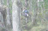
Water levels (i.e., water stage) at each gage station are measured relative to a vertical datum, but ground elevation at each gage station is not usually surveyed. Because many scientists use water depth instead of water levels, EDEN provides estimates of ground elevation at each gage. All ground elevation values were estimated relative to the gage station’s water level measurements. 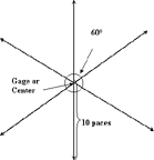
First, water depth was measured at a minimum of six locations in the major vegetation community surrounding the gage station. Then, ground elevation was calculated by subtracting the water depth from the water level reading at the gage. Last, all six ground elevation estimates were averaged. If the area surrounding the gage was dry, the same steps were performed but by optically estimating ground level relative to the gage water level reading. More detail can be found here. Note that these ground elevation estimates are not used in the DEM (digital elevation model) which is used to create the interpolated water depth surfaces. Data release: https://doi.org/10.5066/P13M7CRD |
| Vegetation Community: |
|
Vegetation community at the gage, field descriptions are categorized into major communities for freshwater and tidal gages. Choices for freshwater gages:
Choices for tidal gages:
Data release: https://doi.org/10.5066/P13M7CRD |