The Journey to Restore America's Everglades - Recover Home Page
National Park Service Home Page South Florida Water Management District Home Page U.S. Army Corps of Engineers Home Page U.S. Geological Survey Home Page
Everglades Depth Estimation Network (EDEN) for Support of Biological and Ecological Assessments
Data
EDENapps
xyLocator
Information
Photo of a trail through the woods

xyLocator

Important Information

Update: Version 2.0.1 is now available (November 2012), for PC and Mac. See installation information below.

  • Note: We recommend NOT using the Windows extractor to unpack the .zip file containing the xyLocator, as the Windows extractor has trouble with complex zip archives and long path names. We recommend using WinZip or 7zip.
  • Prior versions of the xyLocator required the user to download NetCDF .dll files and the .NET Framework. This is no longer required, as the latest version of the xyLocator is Java-based. All necessary files are included in the zip file (see below), except for the Java installation.
  • Users will need to have 32-bit Java Virtual Machine (JVM) installed on their system before they can run the xyLocator. The 64-bit JVM causes issues with the xyLocator, so if you are running a 64-bit system, please ensure you have the 32-bit JVM installed, not the 64-bit one. Most machines will have the 32-bit JVM installed. Please contact us if you have questions.
screenshot of xy utility

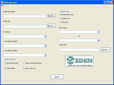
EDEN xyLocator is a program for extracting data from spatial hydrology time-series. Data is extracted for specific x,y positions over the time range supplied by the user. The user can also choose among outputs for water stage, water depth, ground elevation (DEM), and days since dry-down (counting from the start of the specified time range).

The user supplies EDEN xyLocator with a tab-delimited or comma-delimited text file. The first row is a header. Each following row is a point position that the user wants extracted from the EDEN dataset. The row must include a position name, x coordinate and y coordinate. Coordinates must be in UTM, zone 17N, NAD83 projection.

Installation

Prior versions of the xyLocator required the user to download NetCDF .dll files and the .NET Framework. This is no longer required, as the latest version of the xyLocator is Java-based. All necessary files are included in the zip file (see below), except for the Java installation. Users will need to have 32-bit Java Virtual Machine (JVM) installed on their system before they can run the xyLocator. The 64-bit JVM causes issues with the xyLocator, so if you are running a 64-bit system, please ensure you have the 32-bit JVM installed, not the 64-bit one. Please contact us if you have questions.

User's Guide (pdf, 204 KB, updated November 21, 2012)

You will need the following files:

  1. EDEN xyLocator zip file (.zip, 92MB, currently at 2.0.1, Version 2.0.1 updated November 6, 2012). The .zip file can be saved to any location on your computer. Select the appropriate version for your system. Please see note above about unzipping the .zip file.
    • Windows (for 32- and 64-bit versions - please see note above regarding the JVM)
    • Mac (Please note there may be some display issues with the Mac version.)
  2. JavaSE-1.6

Required User Input Files:

  1. EDEN DEM file for ground elevation
  2. EDEN daily water-level surfaces (must be in NetCDF file format (.nc))
  3. x,y points files (see User's Guide below for more information)
We're looking for feedback! Please contact us.

The EDENapps are no longer available on CERPZone. Java-based versions of EDENapps are downloadable at: http://sofia.usgs.gov/eden/edenapps/index.php

Technical support for this Web site is provided by the U.S. Geological Survey
This page is: https://sofia.usgs.gov/eden/edenapps/xylocator.php
Comments and suggestions? Contact: Bryan McCloskey
Last updated: June 17, 2020 08:09 PM (BJM)