
Everglades Depth Estimation Network (EDEN) for Support of Biological and Ecological Assessments
[ Station Information | Data Links | Datum Information | Ground Elevation/Vegetation ]
| Station Information | |
|---|---|
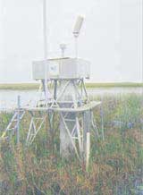
| EDEN Station Name: | SH4 |
| Operating Agency: | USGS |
| Latitude (DMS) NAD83: | 25°25'24.55" |
| Longitude (DMS) NAD83: | -81°03'37.61" |
| UTM Easting Zone 17N (meters NAD83): | 493921.4 |
| UTM Northing Zone 17N (meters NAD83): | 2811842.5 |
| Location Area: | Coast of Gulf of Mexico |
| Location Description: | Shark River |
| Real-time data (daily): | Discontinued |
| Used in EDEN surfaces: | No |
| Data Links |
|---|
[Information about these links] |
Available parameters: (from EVE website)
|
| Datum Information | |
|---|---|
| Vertical Datum for Water Level Data: | NAVD88 |
| Vertical Conversion at Gage (ft) used by EDEN (NGVD29 to NAVD88): | -1.44 |
| Help | |
| Why are all gage data not referenced to the same datum? | |
| How do I convert data at a gage from one datum to another? | |
| How were the vertical conversions at gages determined by EDEN? | |
| Ground Elevation and Vegetation Information for SH4 | |
|---|---|
| [How was this collected?] | |
| Major Vegetation Community | |
| Vegetation Community: | Forest |
| Average Ground Elevation (ft) NAVD88: | 0.37 |
| Maximum Ground Elevation (ft) NAVD88: | 0.42 |
| Minimum Ground Elevation (ft) NAVD88: | 0.32 |
| Number of Measurements: | 6 |
| Collecting Agency and Date: | USGS, July 2008 |
| Data release: https://doi.org/10.5066/P13M7CRD | |
| Leaflet Map | |
|---|---|
|
Leaflet Map (showing location of gage SH4). This map requires enabled JavaScript to view; if you cannot fully access the information on this page, please contact EDEN Data Help References to non-U.S. Department of the Interior (DOI) products do not constitute an endorsement by the DOI. |