Average Ground Elevation within a Vegetation Community
Water depth was measured or ground elevation was surveyed at a minimum of 6 locations in the major vegetation community surrounding the water level gaging station. For water depth measurements, the ground elevation at each site was calculated by subtracting the water depth from the water level reading at the gage. The ground elevations for all measurements were averaged to compute the reported value.
The basic protocol for collection of data at a water level (stage) gage:
- The water level was recorded from the staff gage at the stage gage or at a nearby location. In the case of an unavailable or missing staff gage, the water depth was measured at an reference mark (R.M.) or well. GPS coordinates were collected at every staff gage.
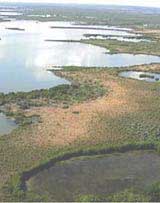
- The major vegetative community at the stage gage was identified.
- Water depth was recorded or ground elevation was surveyed directly at 6 random locations at least 10 meters apart and distributed around the gage in the major vegetative community. Data was collected along 6 spokes radiating out from the gage that are 10 paces long (approximately 10 meters). The spokes were aligned in the following directions: 0°, 60°, 120°, 180°, 240°, and 300°.
- Measurements were not made in disturbed locations, such as in airboat trail or where a helicopter has landed. If a disturbed area was located, the data collector continued walking away from the gage and measured in an undisturbed area. GPS coordinates were collected at every measured point.
- For water depth measurement, the measurements were performed using a surveyor's level rod with a flared rubber base. The measuring stick was allowed to rest on top of the bottom surface. Every data measurement was recorded.
- For surveyed measurements, any standard survey equipment such as optical survey is utilized to measure the ground elevation.
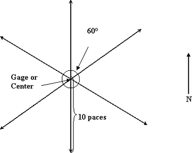
- If the gage was on the edge or transition of a community, a judgment was made to determine the major vegetation community. The data collector walked 20 paces from the gage into the adjacent major community and used that as the center point to begin walking the "spokes".
- Water depth was also recorded or ground elevation was surveyed at 3 random locations at least 10 meters apart and not more than 400 meters from the gage in the next major vegetative community. If there was no next major vegetative community within 400 meters of the gage, none available was recorded. If more than one vegetative community was identified, then both are reported. These points were centered twenty paces into the community from the edge, with the 10-pace spokes oriented at 0°, 120°, and 240°. Measurements were not collected in communities that were too small to conduct the random measurements.
- NA is recorded if the major or secondary vegetation community was dry during the site visit and no ground elevation could be computed.
- Data release: https://doi.org/10.5066/P13M7CRD